Samaria's strategic high ground is essential to Israel's security!
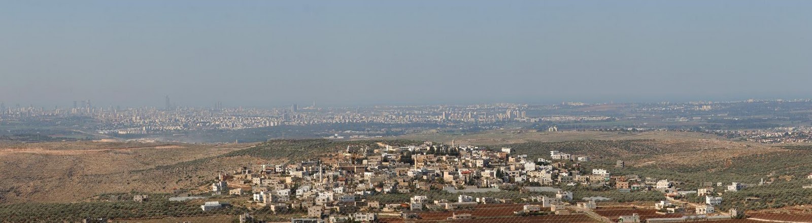 |
| The low-lying Tel Aviv Metropolitan Area (background), as seen from the Heights of Samaria. Click on picture to enlarge. |
Highlands - whoever controls the Shomron mountain range also controls the low-lying regions on each side below. This means the heavily populated Gush Dan, Sharon and Carmel Coast regions along the coastal plain to the west and the strategic Jordan Valley to the east would both be at the mercy of any foreign power that would hold the Shomron. The strategic value of the Shomron mountain range - the spine of which runs north-south for seventy kilometers and which overlooks to the west the majority of Israel's populated areas - is immense. One only needs to visit any of the Shomron settlements or outposts, look towards the sea and the strategic advantage of these highlands will become immediately obvious. The following images illustrate the threat posed to the millions of Israelis living below as well as to industry, infrastructure, military installations and Ben Gurion Int'l Airport if Israel would cede control of the Shomron to any hostile power.

Territorial Depth - The pre-'67 borders (actually not a recognized border at all but merely the 1949 cease-fire line) that defined Israel for the first 19 years of its existence - the "Auschwitz" borders as Abba Eban once put it - are simply indefensible. The coastal strip, shown at right, is home to almost three-quarters of Israel's Jewish population and most of her infrastructural and industrial base. Just 15 kilometers wide at its narrowest point, the pre-'67 lines (without the Shomron) represent an existential threat to the Jewish State. While a narrow waist may look good on a woman, it looks terrible on the map of a country as surrounded, threatened and embattled as Israel. The Shomron adds vital strategic depth to the country's outline and serves as a buffer zone for the crowded coastal strip to its west and for the Jerusalem area to its south.

 |
Without the Shomron, Israel has a zero margin for error during wartime. Qalqilya (right), a West Bank Palestinian city just over the
Green Line, is a stone's throw from major urban centers in the Sharon region. An Israeli retreat back to the pre-'67 lines would put Ra'anana and Kfar Saba within easy range of enemy fire, as can be seen in this satellite photo (click to enlarge). |
Commanding Views -
through a telephoto lens from the Samarian settlement of Peduel, which is not included in any
"settlement bloc", 25 kilometers east of Tel Aviv:
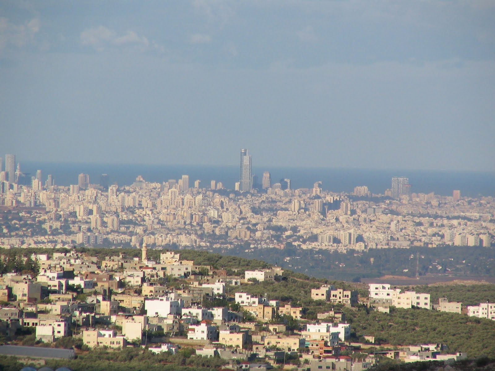 |
| Photo: Alexander Lysyi The view of Greater Tel Aviv (Arab village Dier Balut in foreground) from southern Shomron when in Israeli control... |
 |
| The view of Greater Tel Aviv from "Palestine" (southern Shomron) when in enemy control? |
 |
| The view of the Hadera power station, one of Israel's largest, together with nearby residential areas, lying exposed and vulnerable on Israel's soft underbelly - the coastal plain. This photo was taken with an ordinary camera from the ruins of Homesh, a Jewish Northern Samarian settlement destroyed by the Sharon government during the 2005 Disengagement. Imagine the havoc an enemy could wreak on the Israeli population and industry were it to control this part of Samaria, which is not included in any "settlement bloc".  southern Samaria. If a belligerent Palestinian state were to be established here as a consequence of a Two State Solution, Israel's gateway to the world could be slammed shut. |
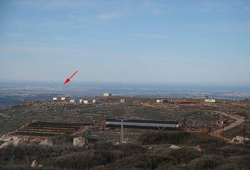 |
| The Har Bracha settlement, perched along the spine of Samaria's Central Mountain ridge, overlooks Israel's low-lying coastal plain. This yishuv, which is not part of any "settlement bloc", towers nearly 900 meters above sea level and provides a bird's-eye view of the Greater Tel Aviv area, as seen in the background. Red arrow points to the Azrieli Center, Tel Aviv's landmark skyscraper office complex. |
 |
| The strategic Jordan Valley (Mountains of Gilead in background) as seen from the Samarian settlement of Migdalim. Just a half hour's car ride east of Israel's major population centers, Migdalim (meaning "Towers") is one of several Shomron settlements that guard Israel's vital eastern flank. It too is not included in any of the "settlement blocs". |
 |
| Good night, Tel Aviv, Samaria is watching over you. The Karnei Shomron settlement can be seen here against the backdrop of Gush Dan (Greater Tel Aviv area), just 30 kilometers in the distance. Photo taken from the Chavat Gilad outpost (Gilad's Farm) in the heart of Samaria. Click on picture to enlarge. |
 |
| The view of Gush Dan and Israel's low-lying coastal plain from the Western Samarian settlement of Avnei Hefetz. This yishuv too is not part of any "settlement bloc". Click on picture for a closer look. |

Mountain Ridge Shield - The Samarian Mountain ridge runs approximately parallel with Israel's coastal strip, home to about three-quarters of the country's population, industrial capacity, financial institutions, key fuel depots and transportation arteries. Rising to heights of nearly 900 meters, the western ridge forms a natural land barrier protecting the coastal plain from threats emanating from the east. Moreover, the ridge provides vital protection for Israel in case of a wartime mobilization. History has shown that the transition from Mideast peace to war is abrupt and unpredictable. Three-quarters of the Israel Defense Forces are reservists who need quick, unfettered access to the roadways in case of a call-up. Materiel must also be moved quickly from various points throughout the country to the various fronts. It is estimated that the IDF requires 50 hours to effectively mobilize.
Were Israel forced to demilitarize Samaria, she would be left with no strategic depth and a mere 5-10 hours of early warning time, way too little to mobilize the reservists, leaving Israel's "Soft Underbelly" vulnerable to an enemy invasion. Even with Israeli control of the strategic Samarian mountains, a sudden and unexpected Arab military offensive, especially on several fronts simultaneously, would be frightfully taxing on the IDF's ability to mobilize. Thus, only Israeli control of the mountain ridges would allow for a successful reserve call-up and for halting an enemy surprise attack. Any hostile power with such control could disrupt and delay a mobilization with disastrous consequences for Israel.
The eastern mountain ridge is no less important. It overlooks the Jordan Valley depression, which rises to an elevation of over 1200 meters and provides Israel with a virtually impenetrable tank barrier. From the eastern Shomron Mountain ridges, even a small Israeli force can neutralize a large enemy ground invasion, giving the reservists the valuable time needed to arrive. This is an advantage not to be underestimated. Although two-state solution advocates will claim that topography is no longer relevant in today's age of ultra-sophisticated modern weaponry, in fact the very opposite is true. Hi-tech weapons systems used against Israel would require her to react and mobilize all the more quicker, leaving her with almost no margin for error (for the full story, read Samaria's Strategic Value). Technology is not infallible. Samaria's strategic height and depth would likely enable Israel to overcome any technological, intelligence or operational failure that may arise on the battlefield. Moreover, Israel's sophisticated high-tech weapon systems of today will soon enough become low-tech tomorrow. Don't let the left-wing spinmeisters fool you - high ground still trumps hi-tech. Missiles can destroy but only tanks and ground troops conquer. Without the Shomron Mountain ridge shield, Israel's very existence could be threatened.

Airspace Depth - Control of the Shomron along the vertical axis does not end at the 1016 meters above sea level pinnacle of Mount Hatzor, the highest and southernmost peak along Shomron mountain range - it actually extends another 25 kilometers or so up into the atmosphere. While we may be unaccustomed to thinking about the strategic properties of airspace, in fact it is crucial to Israel's security. Control of the Shomron means that Israel can deploy its air defense systems along the Samarian
hilltops in order to intercept enemy aircraft from forward positions and not from the heavily populated coastal plain. Short-range radar and early-warning systems situated on the coastal plain would have their line-of-sight blocked by the mountain ridge. Also, if the airspace above the Shomron was in hostile hands, Israel would have no warning time to intercept attacking aircraft. It takes just three minutes for an enemy fighter bomber to traverse the 45 miles separating the Jordan River and the Mediterranean. If Israel had less than three minutes to react, her ability to adequately defend herself by means of fighter interceptors or anti-aircraft missiles would be doubtful. It goes without saying that if the airspace above the Shomron was in hostile hands, Israel would have no warning time to intercept attacking aircraft.
 |
| Early warning radar systems placed along the mountain ridge (left), which allows an unobstructed view eastward clear to the horizon, gives Israel the necessary time to identify and destroy incoming enemy aircraft. Prior to 1967, when the Shomron was under Jordanian occupation (right), the Israeli radar line of sight was blocked by the mountains. |
Indeed, today's hi-tech will soon become tomorrow's low-tech. Yet, Samaria's high ground will remain so forever. U.S. military experts have long recognized this immutable fact and have repeatedly cautioned Israel against abandoning the mountain ridges of Samaria:
"It is unthinkable that Israel would return to the '67 borders in the West Bank, which would deny the Israeli people the defensible borders that are vital for them. Even in the era of advanced military technology there is a decisive importance to strategic depth and terrain conditions for national security." -- Lt. Gen. Earl B. Hailston, Commander U.S. Marines in Iraq/Afghanistan.
“I believe if Israel were to move out of the...West Bank, it would increase instability and the possibility of war, increase the necessity to preempt in war, and the possibility that nuclear weapons would be used to prevent an Israeli loss, and increase the possibility that the US would have to become involved in a war." -- Admiral Bud Nance, testimony to U.S. Congress, 1991
“Missiles fly over any terrain feature, but they don't negate the strategic significance of territorial depth. The key threat to Israel will remain the invasion and occupation by armored forces. Military success requires more than a few hundred missiles. To defeat Israel would require the Arabs to deploy armor, infantry and artillery into Israel and destroy the IDF on the ground. That was true in 1948, 1967 and 1973, and it remains true in the era of modern missiles.” -- General (ret.) Al Gray, former Commandant, US Marine Corps
"Israel should not withdraw from Judea and Samaria, lest it fail to provide security to its People. It is impossible to demilitarize Judea and Samaria effectively" -- 100 retired Generals and Admirals (Oct. 1988, Washington Times)
"As a soldier I would tell you that the pre-'67 borders are not defensible in the long run for Israel. They absolutely cannot live with those borders with those distances" -- Gen. John Foss, the former commander of the U.S. Army's 82nd Airborne Division
"If you have a country that's a sliver and you can see three sides of it from a high hotel building, you've got to be careful what you give away and to whom you give it." -- U.S. Secretary of Defense Donald H. Rumsfeld, August 6th, 2002
 |
"I cannot defend this land (Israel) without that terrain (West Bank)...The West
Bank mountains, and especially their five approaches, are the critical terrain.
If an enemy secures those passes, Jerusalem and Israel become uncovered.
Without the West Bank, Israel is only eight miles wide at its narrowest point.
That makes it indefensible."
-- Lt. General (ret.) Tom Kelly, chief of operations in the 1991 Gulf War |
 |
| This little-known map, part of a six-page memorandum prepared by the Pentagon right after the 1967 Six Day War, illustrates what America's best military minds considered to be the minimum territory Israel needed to defend herself (shaded areas). General Earle Wheeler, Chairman of the U.S. Joint Chiefs of Staff, included all of Judea and Samaria as areas essential for Israel's security. As it contradicted U.S. policy of land- for-peace, it was quickly buried. Only in 1983 was it declassified and made public. Click here for more information regarding General Wheeler's report. |
Watch this important five minute Youtube video "Israel's Critical Security Needs":
bbbbbbbbbbbbbbbbbbbbbbbbbb
The 2005 expulsion (euphemistically labeled "Disengagement") from Northern Samaria left the settlement of Homesh
destroyed and ethnically cleansed of Jews. This one-minute video explains its strategic importance to Israel:
 |
| The late afternoon Tel Aviv skyline as seen from Samaria. Arab village in foreground. Click on picture to enlarge. |